.avif)
Published May 20, 2026
Xona Space Systems: Advancing Precision PNT Beyond GPS
Xona Space Systems: How Next-gen Systems Beyond GPS is Redefining Precision PNT for a Connected World

Xona Space Systems: How Next-gen Systems Beyond GPS is Redefining Precision PNT for a Connected World
PNT stands for Positioning, Navigation, and Timing, which refers to the system of technologies used to determine location, provide navigation data, and synchronize time across various applications.
Every second, billions of devices around the world rely on PNT (Positioning, Navigation, and Timing). It underpins the rhythm of modern life, quietly powering everything from food delivery and ride-sharing to global trade, emergency response, and time-sensitive infrastructure.
Every time you order an Uber or track your meal on Uber Eats, PNT is at work. It guides packages across continents, enables real-time navigation for millions of drivers, and ensures ambulances reach those in need without delay. PNT doesn’t just tell us where we are—it tells our systems when to act.
Beyond mobility, it functions as the invisible clock of modern infrastructure. Every timestamp on a bank transfer, every millisecond in stock trading, and every signal handoff between cell towers depends on GPS system time. Without it, our financial systems would stall, communications would falter, and critical global infrastructure would begin to fail.

Since the earliest days of exploration, humanity’s ability to navigate the world across both place and time has shaped the course of civilization. Celestial navigation opened the seas to transoceanic travel. Long-wave radio systems enabled aircraft and military fleets to coordinate across vast distances. The arrival of satellites introduced a new level of precision that transformed both military operations and civilian infrastructure, with GPS emerging as one of the most profound technological achievements of humanity.
Over the past century, PNT technologies have advanced in regular, exponential leaps. Each generation has reduced error by an order of magnitude, expanding the boundaries of what is possible. Like Moore’s Law in computing, each leap in PNT accuracy creates not just improvements, but entirely new market opportunities. What began with kilometer-level estimates has evolved into sub-meter precision and nanosecond timing, turning spatial and temporal data into one of the most critical and invisible layers of modern infrastructure.
In the decades ahead, that curve is expected to steepen even further. Reed’s Law reminds us that as systems become more connected, the value of each additional node or improvement grows exponentially. In the context of positioning and timing, this means that each jump in accuracy or reliability unlocks not just incremental utility, but a cascading wave of new capabilities. However, as the range of PNT-dependent systems continues to expand, the gap between what GPS can offer and what modern applications demand is becoming increasingly difficult to ignore. Industries that once tolerated signal drift, latency, or loss are now encountering real constraints on growth and performance.
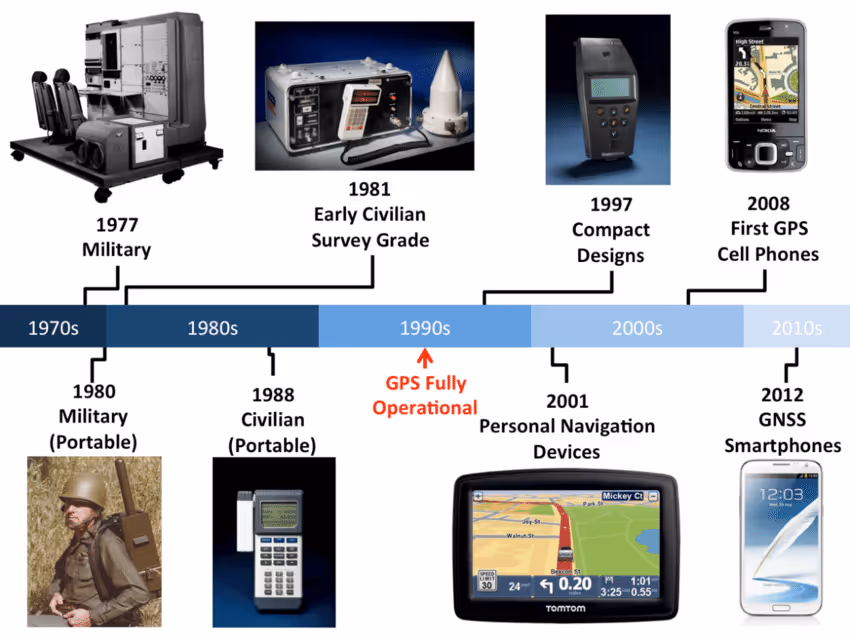
Originally designed for military navigation in the 1970s, GPS was never architected with the level of redundancy or resilience intended to support the immense complexity of today’s global digital infrastructure. Its signals, transmitted from satellites 20,000 kilometers above Earth, arrive weak and are easily disrupted by buildings, natural terrain, and even atmospheric interference. In urban areas, these limitations cause GPS accuracy to degrade by tens of meters and has a growing vulnerability to jamming and spoofing in both civilian and military contexts. As the reliability declines, the consequences extend far beyond missed turns, momentary signal loss, or delivery delays.
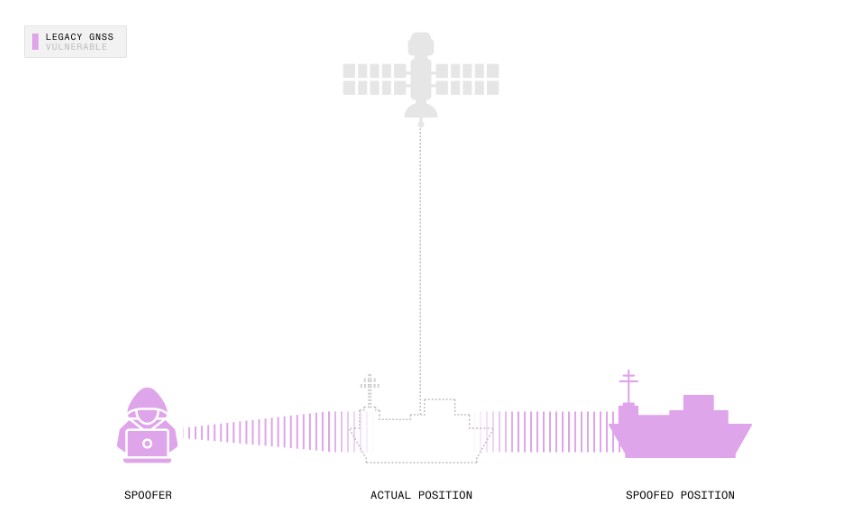
At the same time, security threats that were once theoretical have become mainstream. Spoofing, where an attacker broadcasts forged GNSS signals to mislead receivers, now affects aviation, maritime operations, mobility networks, and critical timing infrastructure. Legacy GNSS systems were never designed to authenticate the distance-measuring signals they rely on, which means receivers have no reliable way to verify whether a satellite transmission is genuine. As low-cost transmitters become more capable, attackers can cause aircraft to misjudge altitude, ships to drift off course, and networks to operate on falsified time. These vulnerabilities reflect a deeper architectural limitation in GPS and other GNSS constellations, which were built for an earlier era with very different security assumptions and far less dependence on trusted timing. Entire industries now face mounting operational risks with increasingly serious consequences.
While ground-based augmentation systems like RTK networks, Wi-Fi triangulation, and 5G positioning improved accuracy in localized settings, they remain costly, fragmented, and still reliant on GPS—falling short of a scalable, next-generation solution. As we emphasized in our GPS Playbook, “GPS is a space-based technology that has generated trillions of dollars in economic value and some of the largest venture outcomes in history.”
Against this backdrop of inherent limitations, dependencies, and scalability constraints in existing PNT technologies, the need for a new path is clear. We believe it will require a fundamentally new architecture that is satellite-native, commercially scalable, and purpose-built to deliver secure, high-accuracy positioning and timing at global scale.
Building the future of global navigation requires a team that understands both the challenges of space-based infrastructure and the real-world constraints of industries reliant on PNT.
Xona was founded by a group of eight engineers who first met at Stanford University’s Aero and Astro Department over a decade ago. After graduation, they pursued paths that spanned both cutting-edge aerospace programs and foundational GPS research. CEO Brian Manning led structural design work on the Falcon 9 at SpaceX, developing an appreciation for the fragility of current navigation systems in increasingly automated environments. CTO Dr. Tyler Reid earned his Ph.D. at Stanford’s GPS Lab, then brought that expertise to Ford, where he worked on localization for autonomous vehicles. Around them, others’ experience spanned Blue Origin, Maxar, BAE Systems, and the U.S. Air Force.

Reuniting in 2019, the Xona team aligned around this conviction that the legacy GPS system was not built for the connected, autonomous, and contested world ahead. PNT has long remained one of the last untouched domains, anchored in static, state-owned infrastructure.
The team looked to models like Starlink and Planet, which reimagined broadband and Earth observation—two sectors once monopolized by public agencies. Rather than retrofit aging government systems, they saw an opportunity to do the same for satellite navigation by building a fundamentally new architecture rooted in commercial demand, because what most who question the market for premium GPS miss is that while GPS has long been treated as a free public utility, the cost of missed performance is not. Enterprises spend over $20 billion annually on GPS hardware and augmentation services, not to unlock new capabilities, but to work around the system’s limitations. That spending is a signal that the world is ready to pay for better PNT capabilities, if only a better system existed.
.png)
Xona’s answer is PULSAR, the world’s first commercial high-precision PNT service delivered via a dedicated constellation in Low Earth Orbit (LEO). Unlike traditional GPS, which relies on large, government-operated satellites in Medium Earth Orbit (MEO), Xona’s system uses small, low-cost satellites positioned 20 times closer to Earth. This enables a 170x stronger signal, lower latency, and vastly improved resistance to jamming and interference. What makes Xona different from previous efforts to enhance GPS comes down to three fundamental innovations:

While Xona is ultimately positioned to become the true successor to GPS, it begins by playing a critical augmenting role. The redundancy it provides is essential, particularly as GPS becomes more vulnerable, and PULSAR enhances accuracy by complementing existing signals rather than replacing them outright.
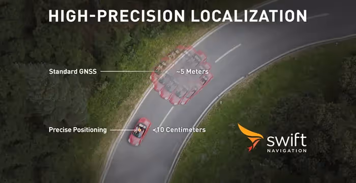
Just as important, PULSAR introduces a new level of simplicity. By shifting complexity into space, Xona enables reliable, centimeter-level accuracy without the need for costly ground correction networks or specialized hardware. Instead, it integrates through a simple firmware update, turning high-precision positioning into a scalable software feature accessible across industries.
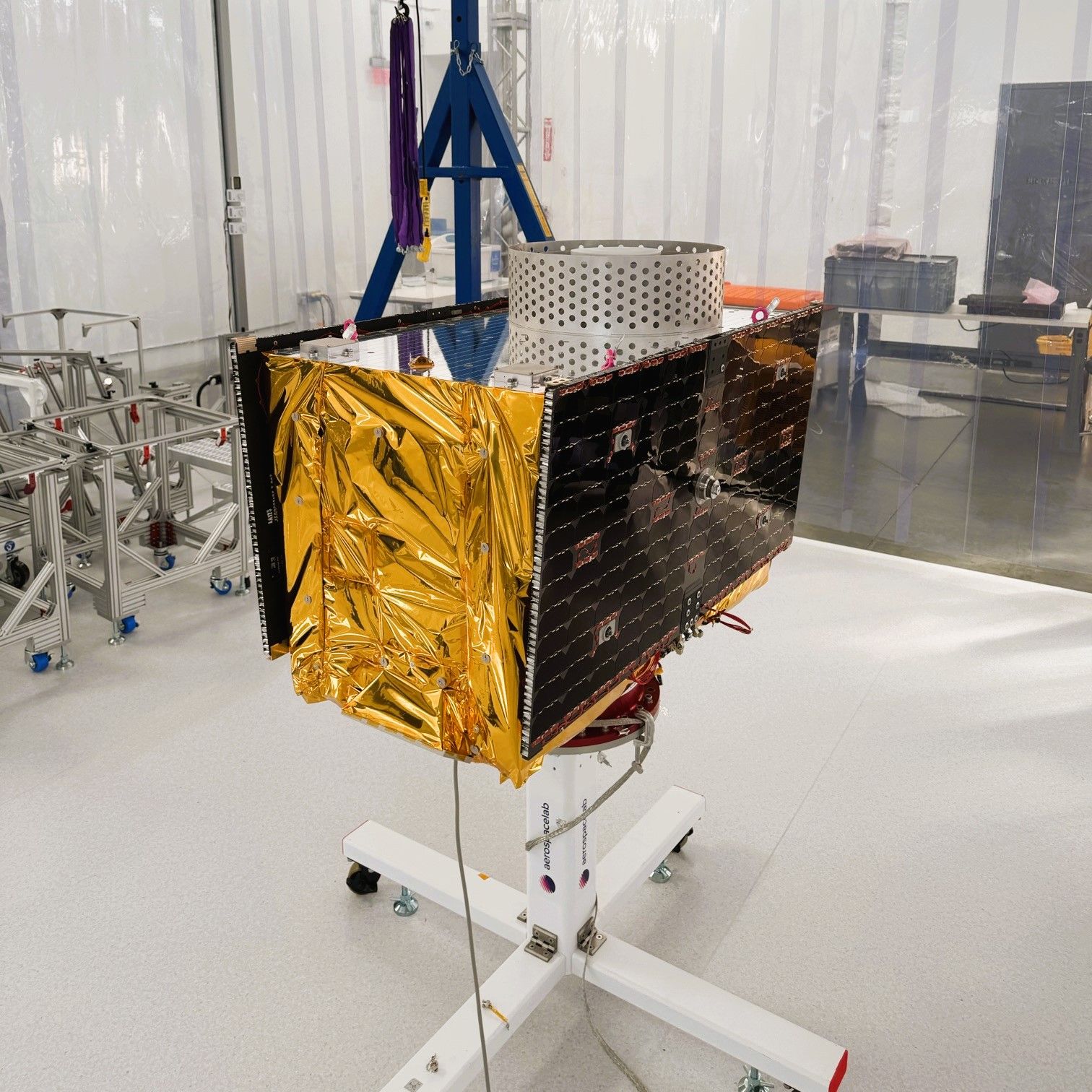
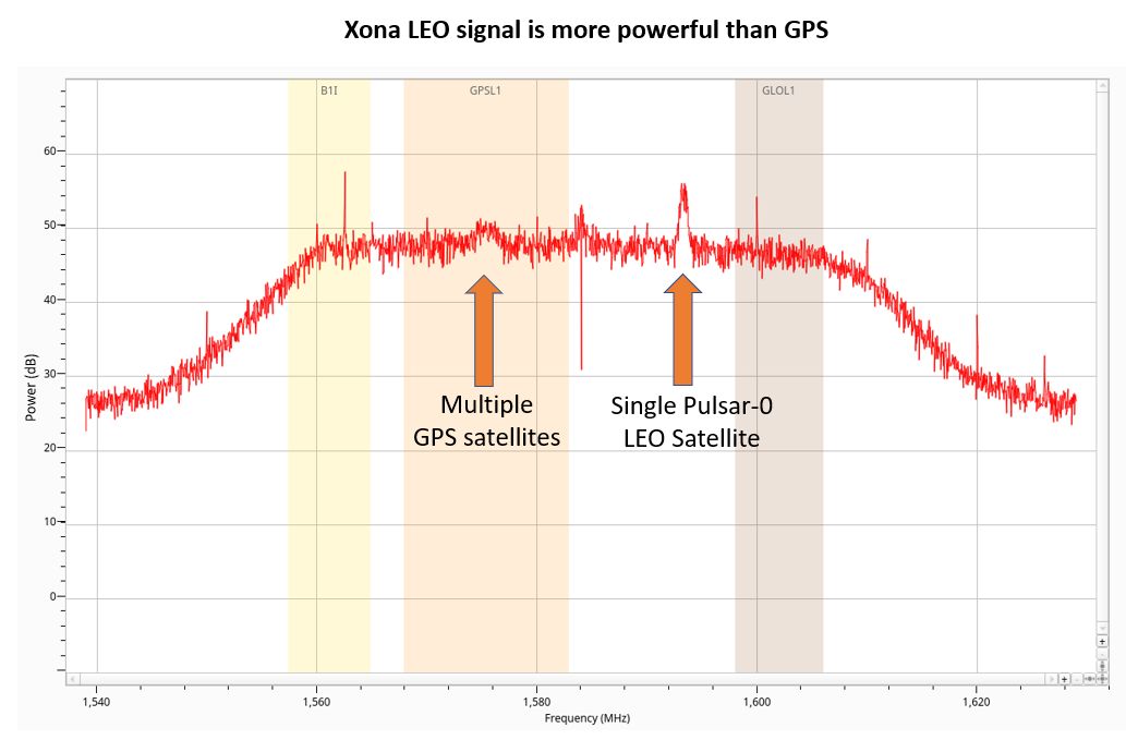
Since its inception, Xona has moved quickly. In 2022, it became the first company to launch a privately funded satellite navigation payload with its Huginn demo satellite. In June 2025, Xona successfully launched Pulsar-0, its first production-class satellite, marking the transition from ground validation to fully operational service in orbit. Pulsar-0 completed full bus and payload commissioning and broadcast the first fully authenticated navigation signal in history from LEO. The satellite has demonstrated stable, encrypted, high-power navigation, delivering what is believed to be the highest-power satellite navigation signal ever recorded, reaching levels up to 100× stronger than GPS while maintaining clean performance across obstructed and contested environments. Live-sky evaluations with commercial and government partners are now underway, with Pulsar-0 demonstrating resilience under jamming, continuity in GPS-denied scenarios, and the ability to receive over-the-air updates that expand capability after launch.
Building on this milestone, Xona has advanced the PULSAR architecture with a series of on-orbit enhancements that move the system well beyond its original design envelope. Pulsar-0 now supports industry-first software-defined upgrades from space, enabling new capabilities to be deployed after launch. Early partner trials have demonstrated 50-70% receiver power savings and improved multipath resistance in dense urban environments. Its encrypted ranging signals have been validated across multiple receiver architectures, and both tiered service levels and hybrid GNSS-LEO operation are now active. Together, these advancements shift PULSAR from high-performance concept to production-ready, next-generation PNT infrastructure.
In June 2025, Xona announced $92M in new funding, including a Series B round led by Craft Ventures, a top-tier venture fund and a $20M STRATFI award from SpaceWERX. This investment brought the company’s total funding to more than $150M and positioned Xona to transition from a single on-orbit demonstrator to a scalable, multi-satellite constellation. The capital enables expansion of manufacturing capacity, continued regulatory progress, and accelerated deployment of the first production satellites for early commercial and government customers, a rollout that actively began in early 2026.
Following the successful in-orbit validation of Pulsar-0, Xona closed a $170M Series C in March 2026. This injection marks a definitive shift from the technical demonstration phase to the global infrastructure phase. The capital is specifically earmarked for scaling production at their Burlingame, California factory to churn out the planned 258-satellite constellation. At full capacity, Xona aims to build more navigation satellites weekly than the U.S. government currently produces in an entire year. In tandem with this hardware scale-up, the funding is driving a global team expansion, establishing strategic footholds in major tech and aerospace hubs like London and Montreal to support international deployment. To maintain an aggressive launch cadence while that high-volume facility ramps up, Xona signed a January 2026 agreement with Belgian manufacturer Aerospacelab to build eight microsatellites, ensuring early commercial coverage by 2027.
The future of navigation extends beyond mobility and maps, it now underpins nearly every emerging layer of our connected world. The demand for trusted, high-precision positioning is creating new business models and everyday utility at unprecedented scale. Xona is already operating across critical frontiers, focusing on high-value applications with minimal integration friction, and collaborating with ecosystem partners to deliver solutions where GPS clearly can no longer keep up.
Notably, multiple recent exciting developments underscore how quickly Xona is moving from technical validation to large-scale operational relevance. In March 2025, Trimble, a global leader in positioning technologies, announced a collaboration with Xona to deliver GNSS corrections via its LEO satellites.
This marks the first commercial integration of PULSAR into a major enterprise-grade platform, enhancing Trimble’s already extensive portfolio of high-prevision positioning services across agriculture, construction, and infrastructure sectors. The partnership highlights the growing commercial demand for resilient, multi-layered PNT solutions and validates Xona’s readiness to support industry-leading platforms at scale.
Xona is gaining traction in the defense sector. In February 2025, the company was awarded a $4.6M contract from the U.S. Air Force Research Laboratory to demonstrate Pulsar’s performance in GPS-challenged and denied environments. The effort focuses on uncrewed aircraft and autonomous systems, where secure, high-precision navigation is essential. Testing will include both simulated and live scenarios using Pulsar-enabled receivers.
Earlier, in November 2024, Astranis selected Xona as its PNT algorithm partner for the Resilient GPS (R-GPS) initiative under the U.S. Space Force. However, the Space Force cancelled the billion-dollar program in early 2026, pivoting to embrace existing commercial PNT solutions instead of building new government-owned constellations. This shift perfectly validates Xona’s core thesis: the future of secure navigation relies on scalable, privately-funded commercial infrastructure like PULSAR, not traditional government acquisitions. In parallel, Xona has expanded its engagement with international navigation agencies. The company participated in the Multi-GNSS Asia Conference alongside ESA, DOT, JAXA, and KARI, a sign of the increasing attention governments are giving to LEO-based PNT as they evaluate more resilient and diversified national infrastructure strategies.

In April 2026, Xona welcomed Senator Ted Cruz, Chairman of the Commerce, Science, & Transportation Committee, to see firsthand how the company is advancing next-generation navigation in Low Earth Orbit. The visit underscored the rapidly growing importance of commercial LEO PNT, demonstrating how it complements legacy GPS to secure and strengthen the systems that power critical U.S. national and economic infrastructure.
.png)
Since Pulsar-0’s activation, Xona has entered a new phase of commercialization, converting early pilots into deployments across timing, infrastructure, and navigation markets. The company signed its first precision timekeeping customers, partnering with leading innovators in timing systems including Hoptroff, Fibrolan, and Timebeat.
In February 2026, marine and industrial electronics giant Furuno also signed an MoU to integrate Pulsar specifically to bolster its timing and synchronization portfolio. Furuno's integration provides heavy industry with atomic-level time synchronization that remains reliable even during active terrestrial signal jamming.
Xona also expanded its navigation ecosystem through an October 2025 MoU with Septentrio, its first European receiver partner. This partnership specifically targets the Uncrewed Aerial Systems (UAS) industry, enabling drones to navigate safely in environments where traditional GPS is compromised. Demand for access to the Pulsar-0 signal has grown rapidly, with live-sky testing consistently operating at full capacity. Customers are using these sessions to evaluate Pulsar’s performance in dense urban environments, under intentional jamming, and in fully GPS-denied scenarios, where the system has demonstrated stable tracking and reliable navigation continuity.
In a domain long dominated by government infrastructure and legacy architectures, we’re proud to back Xona as it leads the revolution in the future of PNT. With over 7 billion people depending on satellite navigation and GPS enabling more than $500B in annual economic value in North America alone, we find ourselves asking: if GPS were rebuilt today as a private system, what would it be worth? Xona is helping us find out, not by replicating what came before or merely closing a performance gap, but by reimagining what’s possible.
From celestial charts to satellites, each leap in our spatial and temporal awareness has expanded the boundaries of what humanity can build. As we enter a new era of autonomy and real-time, interconnected infrastructure, PNT remains the silent foundation of it all. Xona’s work is yet another powerful reminder that space technologies don’t just connect us—they quietly, but profoundly, continue to propel our civilization forward.