Leveling Up Geospatial in the Modern Data Stack
In early 2025, a pivotal moment arrived for the world of geospatial intelligence. For decades, professionals working within Esri’s ArcGIS platform, urban planners, land managers, insurers, infrastructure operators, and many more have relied on Earth observation (EO) data to inform critical decision-making. Yet despite the growing abundance of commercial satellite and aerial imagery, integrating that data into daily workflows has remained a time-consuming and fragmented process. For many users, acquiring the right imagery and preparing it for use could take days, or even weeks, during which its value increasingly diminished.
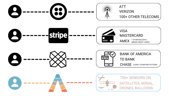
That changed with the launch of the Content Store for ArcGIS, a native integration developed jointly by Esri, the global leader in Geographic Information Systems (GIS) software, and SkyWatch, a company focused on simplifying access to the geospatial data value chain. Available through ArcGIS Online and rolling out to ArcGIS Enterprise, the Content Store enables users to search for, purchase, and immediately use commercial imagery within their existing ArcGIS environment. With a few clicks, users can access all the latest and archival data from providers like Maxar, Airbus, Planet, Satellogic, Urban Sky, and Eagle View, layered directly onto their own projects. Authentication is handled through ArcGIS credentials, and the resulting imagery is instantly analysis-ready. With coverage extending across multiple sensing domains, the Content Store is steadily evolving into a unified interface for discovering and acquiring mission-critical geospatial data.
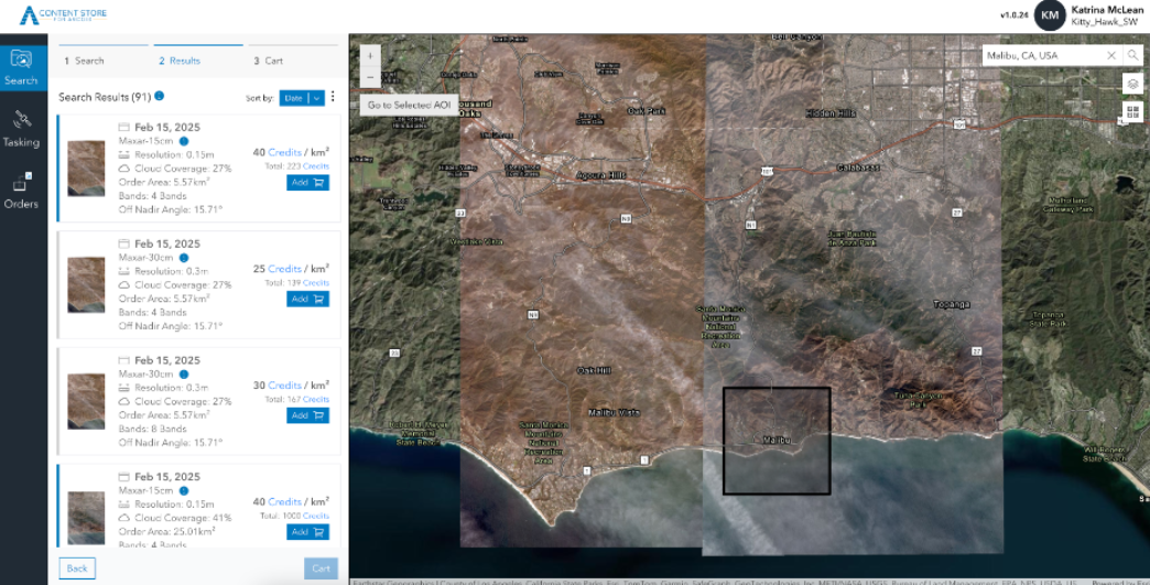
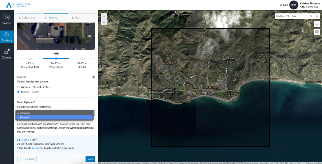
This shift did not happen overnight. SkyWatch launched the world’s first API for geospatial data in 2016 and, as a longstanding member of the Esri Partner Network, the company first introduced an ArcGIS Pro plugin in 2023, offering early glimpses into what a more streamlined experience could look like. In mid-2024, SkyWatch formally launched the SkyWatch Content Store for ArcGIS, a web application tightly integrated with ArcGIS Online. The rollout included direct access to very-high-resolution imagery (VHF), with support for custom image capture, map-ready layers, and derived analytics products. Less than a year later, in early 2025, Esri incorporated the Content Store into its broader ArcGIS product suite, creating a seamless, credential-based procurement workflow.
Geospatial professionals no longer need to juggle external vendors or build custom ingest pipelines. Instead, they can browse and acquire imagery using familiar ArcGIS interfaces, publish new layers in seconds, and begin analysis immediately. SkyWatch handles ordering, payments, licensing, and policy enforcement invisibly in the background, allowing users to focus entirely on what matters.
This shift is more than a matter of convenience, as timeliness is often the difference between insight and irrelevance. In wildfire response, a satellite image that arrives two days late shows what was lost, not where to deploy resources. In agriculture, spotting crop stress a week too late can mean missing the window to apply treatment before damage spreads. For insurers, capturing post-disaster conditions in the immediate aftermath can be the difference between a fast-tracked payout and a prolonged, disputed claim. In infrastructure, crews rely on current imagery to verify progress, detect encroachments, or assess storm damage, insights that degrade quickly as conditions evolve. And in logistics, up-to-date visuals of ports, highways, or distribution centers can inform routing decisions, identify bottlenecks, or validate last-mile conditions. Until now, access delays meant analysts often worked with outdated snapshots, limiting what could be trusted and acted on. Integrating EO data directly inside ArcGIS workflows removes a significant amount of lag, turning imagery from a passive archive into a live decision input.

For SkyWatch, this milestone is both a validation and a celebration. It affirms a conviction that has guided the company since day one: the real value of Earth observation lies not in its collection, but in its ability to inform real-world decisions at the moment they matter most. That’s only possible when such data is as easy to access and use as any other part of the modern software stack. In doing so, it repositions geospatial data from a niche product for technical specialists to a foundational layer in the state-of-the-art digital infrastructure of global industries. What SkyWatch has enabled is more than a set of technical milestones, it marks a turning point in unlocking the full potential of Earth intelligence.
The Bygone Days of Fragmented Access
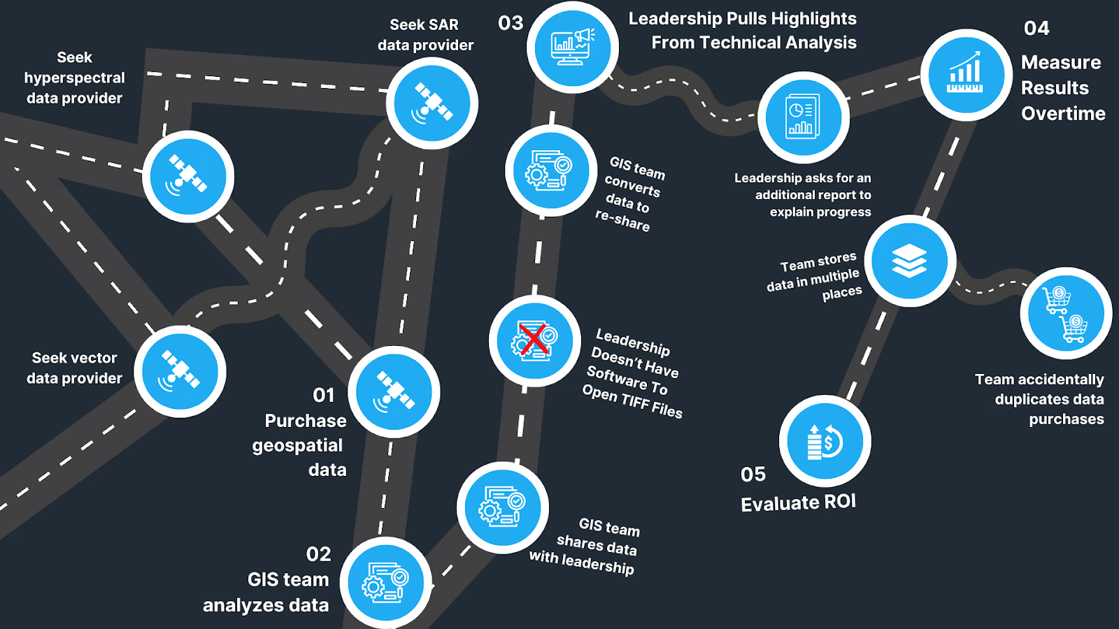
A decade ago, accessing commercial satellite imagery was anything but seamless. While public sources like Landsat and Sentinel provided useful global coverage, professionals who needed recent, high-resolution imagery for real-world decision-making were faced with a maze of obstacles. Finding the right imagery meant identifying a provider, navigating a maze of procurement portals and understanding their licensing structure, creating a custom account, and often negotiating one-off contracts. Once acquired, data often arrived in inconsistent formats, with limited metadata, through different export tools, delivery services, and required hours of preprocessing before it could be used in mapping tools or models. For analysts working in time-sensitive domains, this latency rendered much of the data operationally useless. Traditionally, these workflows were built with defense and government use in mind, and satellite operators had little incentive to cater to smaller or commercial users. Yet, it is becoming increasingly apparent that the long tail of demand holds enormous potential.
For developers building geospatial applications, the complexity was the most pronounced. Satellite data was far from a simple visual layer—it needed to be filtered for cloud cover, reprojected, aligned to specific coordinate systems, and kept continuously up to date. Managing pipelines for multi-sensor ingestion meant stitching together a patchwork of APIs, queues, storage systems, and transformation logic. Developers had to normalize metadata, monitor usage limits, reprocess failed acquisitions, and ensure all different types of new data flowed in as archives expanded. In practice, teams were forced to build and maintain a costly infrastructure before they could build basic features.
Applications that relied on up-to-date EO data had to account not just for the spatial accuracy of their models, but for the underlying volatility of the data supply. Images would drop out of availability, change in licensing status, or arrive too late to be relevant. As new satellites launched and old ones decommissioned, developers were forced to constantly update their integrations to stay current. This overhead made it difficult to build scalable products that relied on commercial imagery. Most startups and tools opted to stick with static or open datasets, not because they were better, but because they were manageable.

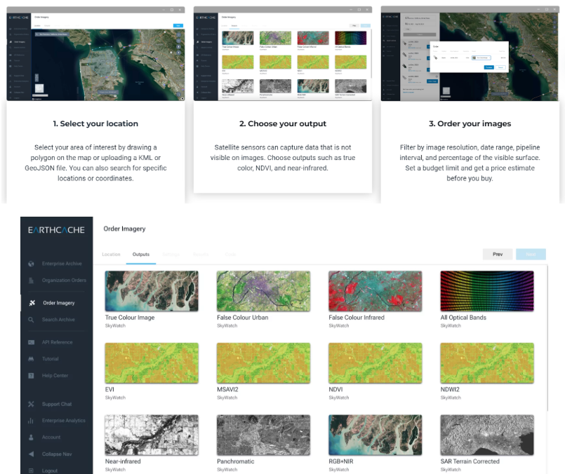
SkyWatch was founded in response to this problem. After winning a NASA Space Apps Challenge in 2014, the founding team—led by CEO James Slifierz, COO Dexter Jagula, and Platform Engineer Roland Singh, began developing what would become one of the first developer-focused APIs for EO imagery. Their first product, EarthCache, aimed to consolidate disparate satellite feeds into a unified query layer. Developers could filter by date, cloud cover, sensor type, or resolution, and receive consistent outputs via a single endpoint. EarthCache dramatically reduced the integration burden, but adoption still required technical fluency. Organizations without in-house engineers often struggled to make use of it without external support.
In 2017, Joel Cumming joined the leadership team as CTO, bringing deep experience from BlackBerry’s advanced analytics group and Kik’s large-scale messaging infrastructure. His arrival marked a new phase of platform expansion and enterprise readiness. Building on the foundations of EarthCache, SkyWatch launched its second major product, TerraStream, to support imagery providers on the supply side of the equation. TerraStream helped satellite operators onboard their data, manage distribution, and monetize archive content. The product created a shared backend for providers who otherwise lacked the tooling to serve commercial customers at scale.
SkyWatch became the most trusted platform for both sides of the ecosystem. But over time, it became clear that an API-first model could only do so much good. EarthCache and TerraStream dramatically reduced the technical burden of integrating satellite imagery, but they couldn’t fully address the organizational challenges that users faced downstream. Many teams still lacked centralized tools to manage geospatial data across users and projects. Procurement workflows remained inconsistent across vendors, and integrating imagery into platforms like ArcGIS or QGIS still required custom workarounds. Much of the data ended up stored in general-purpose systems like Google Drive or SharePoint, which was never designed for the size, format, or cadence of geospatial content. These limitations were the result of a broader ecosystem that lacked the mature infrastructure to support scalable geospatial operations.
SkyWatch took customer feedback to heart, and forged a deep understanding that access alone wasn’t enough for users to succeed in the long term; they needed to launch a modern system to manage, share, and operationalize imagery across their workflows. The company began re-architecting its platform from the ground up. Instead of a loose collection of endpoints, SkyWatch built a coordinated set of services for identity management, tasking and archive access, ordering, fulfillment, payments, policy enforcement, and geolocation. These core services now underpin every SkyWatch product.
The first major application to take advantage of this architecture was HUB, launched in 2024 as a centralized system for enterprise users. HUB offered much more than access: it brought control, structure, and visibility. Customers could manage procurement, monitor usage, approve budgets, and track ROI across teams, all through a single interface. They could store and organize imagery natively, without relying on systems not built for geospatial data. For the first time, organizations could treat EO data not as a one-off input, but as a maintained, governed asset within their operational stack. This marked a clear evolution in SkyWatch, from a developer-first API company to a full-stack infrastructure provider for operational Earth intelligence.
Tools for Every Part of the Value Chain
SkyWatch’s full-stack platform now comprises five interoperable products: EXPLORE for imagery discovery, HUB for enterprise control and governance, MAP for GIS integration, BUILD for developer access, and CONNECT for provider onboarding and distribution. Each of these tools reflects a different stage in the satellite imagery workflow, from discovery to procurement, integration, and delivery, and is designed to function independently or as part of a coordinated system. This modularity gives organizations flexibility while ensuring every layer remains connected.
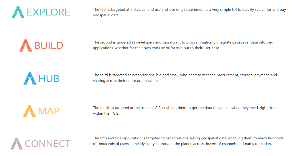
SkyWatch didn’t simply extend its legacy offerings. They were instead reimagined as a modular, interconnected infrastructure layer. Each product serves a distinct role, yet all operate through a shared backend of core services. This architectural consistency allows teams across procurement, operations, engineering, and analysis to work through tailored interfaces while maintaining centralized control and interoperability. Data published through CONNECT flows into EXPLORE and MAP, is governed by HUB, and can be automated via BUILD, forming a seamless, end-to-end pipeline. The result is a scalable system where every transaction is auditable, every asset is managed, and Earth intelligence becomes a repeatable, embedded part of enterprise workflows.
Heralding the Era of GeoAI
The geospatial industry has always been constrained by complexity. The path to insight was slow, brittle, and highly manual, which is why organizations relied on analysts internally and consultants. With SkyWatch’s decade-long effort to simplify data access and integration, that dynamic has already changed significantly. But a deeper catalyst is now in play. The rise of GeoAI is turning Earth observation into what it was always meant to be: a truly intelligent system for understanding change at planetary scale and applying that insight in real time.
As in other industries transformed by AI, the real breakthrough has not come from better algorithms alone. It has come from infrastructure that reduces the cognitive and operational load on users. In financial markets, traders no longer spend hours gathering price feeds—they receive structured, streaming data they can act on instantly. In logistics, managers no longer need to manually reconcile inventories—sensor networks provide real-time visibility across the supply chain. In cybersecurity, analysts do not have to sift through disparate logs—telemetry streams are fed directly into detection models. In each case, the shift was not just making intelligence available, but embedding it into workflows so users could spend less time searching and more time deciding. GeoAI depends on the same foundation. The transformation of geospatial AI hinges on something at its core: getting the right data derived from pixels to the right systems at the right time.
Now, there is an increasing abundance of multispectral, hyperspectral, SAR, thermal, and aerial imagery with rising resolution and frequency. Models trained on this data are becoming significantly more capable, able to detect anomalies, classify land use, forecast conditions, and track change with precision and speed. What once took weeks, such as assessing wildfire damage, evaluating infrastructure, or monitoring deforestation, can now be done in hours, and soon in minutes. What once required dedicated GIS teams is now accessible to decision makers at all levels, delivered through intuitive interfaces that contain only the most actionable information.
SkyWatch sits at the core of this transformation. Its platform connects the world’s most valuable pixels to the workflows that need them. Over the past year, it has expanded coverage across new sensor types, deepened integration with downstream analytics environments, and launched programmatic tasking to make imagery acquisition more on-demand. Users can now request future imagery based on custom parameters and have that data delivered directly into their systems once captured. Most recently, SkyWatch partnered with Eagleview to bring the highest commercially available resolution ultra high resolution (UHR) imagery onto the platform—detailed enough to distinguish individual vehicles, rooftops, and even sidewalk markings. This ultra-precise data expands SkyWatch’s utility across urban, infrastructure, and property-focused applications.These are not new directions, but the continuation of a consistent goal: reduce the friction between data supply and operational use.
And as GeoAI evolves, SkyWatch’s platform is evolving with it. Each layer of the stack stands to become smarter. EXPLORE can use retrieval-augmented generation to help users find the best imagery with natural language or contextual prompts. HUB can learn from procurement patterns to optimize budgets, enforce policy, and flag anomalies. MAP can support AI-assisted workflows like semantic segmentation, change detection, and automated annotation. BUILD allows developers to route imagery into training pipelines, while SkyWatch enriches that content with pre-labeled assets. Even CONNECT enables supply-side optimization, allowing providers to track demand and improve coverage strategies using predictive models.
Meanwhile, the broader spatial AI landscape is converging with geospatial intelligence in powerful new ways. Geo foundation models are beginning to treat the physical world as a core context layer—integrating satellite imagery, terrain data, and time series into their embeddings. Emerging world models are simulating how real-world systems evolve across time and space, unlocking new capabilities in infrastructure planning, risk analysis, and environmental monitoring. At the same time, new classes of sensors are capturing real-world behavior in continuous, spatially grounded streams, and novel AI systems translate these multimodal signals into usable context, further enriching the geospatial layer available to intelligent systems. AI-native development environments now allow users to build workflows using natural language and geospatial prompts, combining vector tiles, remote sensing layers, and user-defined areas of interest into interactive, intelligent applications.
Underneath all of this is a growing need for infrastructure: not just to access the data, but to align formats, support spatial queries, and maintain semantic consistency across modalities. What these new tools require is simple, high-quality, programmatically accessible Earth data. SkyWatch delivers precisely that. As the interface between upstream imagery and downstream intelligence, it enables this new generation of spatial AI systems to function with maximum speed, broader context, and greater reach.

The promise of Earth observation is starting to deliver. Geospatial data is no longer an external input to be consulted only over long timeframes. It is becoming a continuous, embedded source of everyday truth. In this new era, the companies that succeed will be those that stop treating geospatial intelligence as a nice-to-have and begin adapting platforms like SkyWatch to upgrade their intelligence layer. At Space Capital, we’re proud to have backed SkyWatch from the earliest days and to have seen firsthand how much the team has contributed to the industry’s growth and evolution over more than a decade. GeoAI is ushering a new era of a data-driven future, and SkyWatch is its operational backbone.