The 2025 Space Capital Summit panel, Navigating the Future: Resilient GPS & AltPNT, explored how emerging technologies and partnerships are building a more resilient, accurate, & secure future for GPS and alternative PNT systems.
From precision agriculture to financial transactions to national security, the modern world runs on positioning, navigation, and timing (PNT). At the 2025 Space Capital Summit, we convened a panel to examine a critical question: How do we ensure the resilience of these systems in a world where the risks to GPS have never been greater?
The experts featured in the Navigating the Future: Resilient GPS & AltPNT panel were:
Together, we unpacked the vulnerabilities of legacy infrastructure, the rise of alternative PNT (AltPNT) solutions, and the sweeping opportunities for innovation in an increasingly autonomous and AI-powered world.
Why GPS Needs a Backup Plan
GPS underpins an estimated $1.4 trillion in U.S. economic activity. Yet its vulnerabilities are no longer theoretical. From jamming in Ukraine to spoofing in the Middle East, GPS has become a soft target in electronic warfare. As Tom Gillespie bluntly stated: “It’s incredibly urgent. We’re behind—and we’re playing catch-up.”
Tom described mounting concerns in defense circles as China’s BeiDou system accelerates its capabilities. With 45 satellites already in orbit and a more powerful constellation planned for 2027, BeiDou is already surpassing GPS in several domains. Without strategic intervention, the U.S. risks ceding leadership in global navigation.
Building the ‘Starlink for GPS’
Enter Xona Space Systems, where Brian Manning is developing a low Earth orbit (LEO) satellite network designed to deliver precise, resilient navigation signals. As Brian explained:
“What we’re building is essentially the Starlink of GPS—dedicated navigation satellites in LEO, firmware-upgradable for the 7 billion GPS devices already out there.”
By operating closer to Earth, Xona’s Pulsar constellation improves both accuracy and resistance to jamming. Importantly, the system is designed to be backward compatible, so users—from autonomous vehicles to smartphones—can benefit without costly hardware upgrades.
Xona focuses on three key benefits: precision, power, and protection. Whether it’s a driverless car navigating snow-covered roads or a defense unit operating in a contested zone, these capabilities offer a step-change from today’s GPS.
Resilience Through Software and AI
While Xona reimagines the satellite layer, Zephr is reinventing the device layer. As Sean Gorman noted: “Most GPS receivers are low-end commodity chips. Our job is to make them more resilient to interference—whether from buildings in New York or jamming in Ukraine.”
Zephr applies AI to enhance signal interpretation across a distributed network of devices. By aggregating GNSS measurements from many phones or sensors, their cooperative positioning system can filter out bad signals and reinforce good ones.
This approach was tested in Ukraine, where jamming by Russian forces rendered many systems inoperable. By loading Zephr’s software onto locally sourced smartphones, Ukrainian teams gained not only improved positional accuracy—but also the ability to locate the jammers themselves.
“That distributed data set became a powerful tool,” Sean explained. “We could track where jamming was happening and adapt in real time.”
The Case for a Hybrid System
One of the most important takeaways from the panel was that Resilient GPS and AltPNT aren’t in competition—they’re complementary.
Sean described GPS-denied zones as “snow globes”: “When you enter a jammed environment, AltPNT kicks in. When you exit, GPS reacquires and corrects any drift.”
That interplay means future navigation will rely on a multi-layered architecture—space-based systems like Xona, terrestrial networks like Zephr, and software platforms that fuse the two.
Learning from Launch
Brian drew a compelling analogy between today’s navigation ecosystem and the launch sector of the early 2000s. Then, the U.S. faced rising costs and reliance on foreign launch vehicles. By shifting to a “launch as a service” model, NASA catalyzed the rise of SpaceX and restored American leadership.
“Navigation is in the same place now,” Brian argued. “The U.S. government has a clear need, and there’s a rapidly growing commercial market. Embracing navigation-as-a-service could create the SpaceX of GPS.”
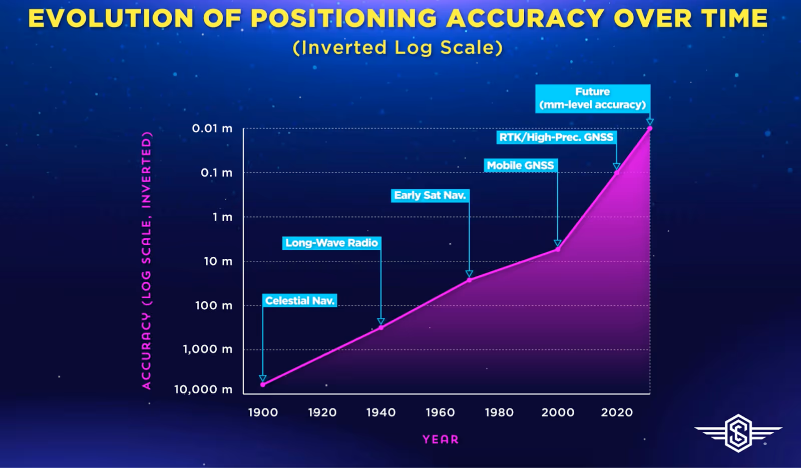
Brian also introduced a powerful framework he calls Reed’s Law of Navigation, based on work by his CTO, Tyler Reed.
It maps navigation technology against accuracy thresholds and associated breakthroughs. From celestial navigation (kilometer-scale) to longwave radio (hundreds of meters), GPS (meters), and now AltPNT (centimeters and beyond), each leap in precision has unlocked new capabilities.
IMAGE: Reid’s Law of Navigation: Evolution of positioning accuracy over time (Source.)
“You couldn’t build Uber without GPS. You won’t build the next generation of autonomy without centimeter-level PNT,” Brian explained.
Use cases are already emerging—from automated construction that saves millions in materials, to rail logistics where positional ambiguity of even a few meters can mean the difference between a full or empty railcar.
The Investor Opportunity
Investors are taking notice. With autonomy on the rise and defense spending expanding, demand for resilient navigation is skyrocketing.
Tom noted a shift in investor attitudes: “Two years ago, it was hard to raise money for this. Now, there’s recognition that PNT is foundational—not just to defense, but to AI, logistics, and infrastructure.”
Brian echoed that sentiment: “Most customers don’t care whether it’s satellites or towers. They care if it works—if it’s accurate, reliable, and affordable.”
This opens the door to a variety of monetization models. Instead of paying once for a GPS chip, customers may soon subscribe to enhanced navigation services, pay per use, or bundle capabilities into connected products.
AI + PNT = Smart Autonomy
As devices become more intelligent, the demands on PNT increase. Sean described how visual positioning systems like those used in AR glasses are powerful but battery-intensive and privacy-sensitive. His team asked: “What if we could get that level of accuracy with GNSS alone—no cameras required?”
Zephr is now broadcasting AI-generated corrections over 5G networks to end-user devices, making it possible to localize with 50 cm accuracy using only commodity chips. This unlocks new form factors, from glasses to earbuds, and feeds next-gen AI systems with high-fidelity spatial context.
“Every AI model is only as good as the data you feed it—and most data is location-tagged,” Sean noted.
Autonomy and the Battlefield
The panel closed by exploring the intersection of resilient navigation and autonomy—both commercial and defense. Autonomous vehicles, drones, and battlefield robots all require extreme levels of PNT precision, security, and uptime.
“When a human’s behind the wheel, you can get away with less accuracy,” Brian said. “When the system is fully autonomous, there’s no room for error.”
And it’s not just vehicle-to-vehicle navigation. Sean described a use case in Japan where accurate smartphone positioning allows autonomous cars to avoid pedestrians—not by detecting them directly, but by awareness of their phones.
“Autonomy is no longer limited to vehicles. It’s a network problem—and PNT is the backbone.”
Brian wrapped up with a memorable analogy: “If you woke up from a 30-year coma, your first two questions would be: Where am I? And what time is it? That’s PNT.”
Machines, too, need to answer those questions—every time they boot up, every time they make a decision. As we enter an era of ubiquitous autonomy, resilient GPS and AltPNT are not optional. They are essential infrastructure.
.avif)