.avif)
Published December 20, 2021
Mapping companies that are improving your everyday life - Part 1
Maps are one of the most revolutionary creations of mankind. Maps and their evolution revolutionize every era in which we live and have lived.

Maps are one of the most revolutionary creations of mankind. Maps and their evolution revolutionize every era in which we live and have lived.
Maps are one of the most revolutionary creations of mankind. As a picture is worth a thousand words and maps are made of millions of pictures, maps deliver an instant understanding of our surroundings because the power of visualization is so intuitive to us. It is an elegant way to make us aware of where we are and can take us to where we want to go in our everyday lives.
But what many people have not realized is that maps have played such an invaluable part in the history of realizing humanity’s prosperity, and they will be an even more integral part in everyone’s daily activities in the journey beyond. From the earliest hand-drawn paper maps to the rise of Geographic Information Systems (GIS) companies, maps have come a very long way. The reliance which we have on maps and mapping technology companies cannot be understated. Maps and their evolution revolutionize every era in which we live and have lived.
In 1569, the Flemish map maker Gerardus Mercator made a decision that changed the way we view the planet. In flattening the planet onto a two-dimensional surface, he chose to preserve the local angular relationships of land masses to make ocean navigation easier, at the same time distorting the size of the land, making it bigger as it creeps closer to the poles.
People named his mapping method the “Mercator projection”, which has laid a foundation of mapmaking and provided guidance to the new human settlement around the world. During the 1846–1860 pandemic, as cholera claimed hundreds of thousands of lives, British physician John Snow was the first person to figure out how the deadly disease was spreading.
By plotting the locations of deaths in London’s Broad Street on a map, Snow discovered a link between cholera cases and contaminated water sources, and his now famous-yet-simple dot map is considered by many to be the start of the field of epidemiology. This event is widely considered the birth of Geographic Information Systems (GIS), a breakthrough in mapping technology.
For a long time, GIS was mostly used by researchers, scientists and urban planners, but now a wide variety of industries and GIS companies have built their own GIS software to explain and surface spatial information and have redefined what GIS and satellite mapping can do. Today, we are going to dive into various applications of GIS mapping technology, from traditional GIS analytical software companies like Esri to new GIS applications such as Yelp and Niantic, and uncover what GIS map companies are doing to improve our everyday lives.

Before the emergence of publicly available digital maps, people used to hold a printout of directions in one hand and the steering wheel in the other to get around and had no clue about the traffic or details about any interesting restaurants or attractions along their routes.
Nowadays GIS mapping companies are using the latest machine learning and AI-powered improvements to push the boundaries of what a map can do for us so we can have the most accurate, up-to-date information about the world exactly when we need it. Check out the digital maps from these 4 mapping technology companies to understand how mapping has evolved and will continue to evolve to impact our day-to-day lives.
Google, having the most widely used digital satellite maps, is always looking for clever ways to improve its navigation features. Google Maps has come out with several updates recently to help you find your directions on the street easier and among them, Live View is the most prominent feature. Live View is powered by a technology called global localization, which uses AI to scan tens of billions of Street View images to understand your orientation.
Live View Mapping works with any walking portion of your journey and with it you can see arrows, directions, and distance markers placed on top of the real world using augmented reality (AR). Live View can show you how far away certain landmarks are from you and what direction you need to go to get there. In many places where Google Maps knows about the precise altitude and placement of objects inside a building, Live View is also able to help you navigate some of the trickiest places indoors including airports, transit stations and malls. If you are catching a plane or train, Live View can help you find the nearest elevator and escalators, your gate, platform, baggage claim, check-in counters, ticket office, restrooms, ATMs and more.

As the major competitor of Google Maps, Apple has been steadily improving its maps’ accuracy, reliability, and availability since its debut in 2012 and sought out ways to really differentiate itself from Google Maps.
While both offer a very user-focused interface that is easy to use, how they present the information is quite different and Apple Maps is aiming to provide a better user experience. Apple takes a minimalist approach to its interface and map design, with color schemes that are easier on the eye and do not overwhelm the users with information, unless the user specifically searches for it or zooms in.
In 2021, The most recent updates coming to iOS 15 add-ons to their approach, bringing Apple brought more detailed, aesthetically looking maps, improvements for commuters, and AR experiences. Across the map, Apple has added elevation data, new road colors, labels, and hundreds of custom designed landmarks such as the Golden Gate Bridge, a new nighttime mode with a “moonlit glow”.
For drivers, Apple Maps added new road details to help drivers see turn lanes, medians, bus, taxi lanes, crosswalks, and bike lanes more clearly. It will also render overlapping complex interchanges in 3D space, making it easier to understand its underlying traffic conditions and decide what lane to take.
For public transit riders, users can now pin their frequent transit lines to the top of the app and keep track of them on Apple Watch – Apple Maps will automatically follow your transit route and notify you to get off when you are approaching the stations. When users exit the stations, they can now use Apple’s version of Google Maps’ Live View through AR to get step-by-step directions as well.

From buying clothes to ordering food, from finding housekeeping or laundry services, we are now so used to finding all the information we need on an app. With the rapid increase in the number of services we can find in our proximity, POI data becomes vital to efficiency. Without an accurate reference of location, finding these services would be difficult.
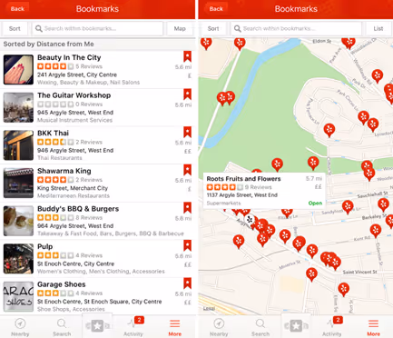
Yelp is one of the earliest POI mapping companies and it has helped shape the way consumers nowadays interact with businesses and locations around them.
With the success of global rollout of Covid vaccinations and local economies reopening this summer, Yelp is seeing a sharp increase in user activities and new business listings. Their data shows Americans are eager to return to normal and are now visiting restaurants like pre-pandemic times, driving a record number of diners. Restaurants have bounced back to 86% of 2019 levels and food businesses recovered to 92%.
Using Yelp’s maps, you can quickly discover the most interesting dining places with verified reviews, find out the most up-to-date business hours, peak periods, and book a reservation ahead of time. If you are a new business owner, you can use Yelp to promote your business, track engagement and leads, respond to reviews, connect with your customers and stand out from the community.
Dataplor is another leading POI mapping company. While Yelp has excellent business data in North America and Europe, up-to-date information about small businesses in the rest of the world is often hard to come by and hard to maintain due to the lack of online presence.
Dataplor focuses on addressing this issue in the emerging markets through an on-the-ground team of contractors. These individuals collect and verify micro-business data and adopts AI to constantly contact the businesses for updates. The satellite mapping company currently has the most accurate small business database for Latin America and Southeast Asia. Its comprehensive verified business POI data powers many applications in mapping, rideshare, food delivery, financial banking, insurance in these areas and are used by many large players such as Apple, Google, Microsoft, Uber Eats, American Express, and city governments.
In Part 2, let's dive into the emerging map companies that are expanding upon the work of these mapping companies and developing it into something so much more.