The Invisible Transformation of Global Industries - Part 1
The modern global economy, and the underlying systems that drive industries, rely on space technologies as the only global infrastructure. Space technologies have become the “invisible backbone” that power the next generation of digital infrastructure, helping coordinate and automate key facets of our global economy.
The modern global economy, and the underlying systems that drive industries, rely on space technologies as the only global infrastructure. Concepts like synchronous time and key attributes in precise positioning form the fundamental building blocks of many of our innovations today. Unseen by human eye, space technologies have become the “invisible backbone” that power the next generation of digital infrastructure, helping coordinate and automate key facets of our global economy. Beyond the Global Positioning System (GPS), Geospatial Intelligence, and Satellite Communications also play a critical role in transforming major industries. Telecommunications, Agriculture, Oil & Gas, Construction, Financial Services, and Insurance all benefit from space-based infrastructure.
Telecommunications & Information Technology
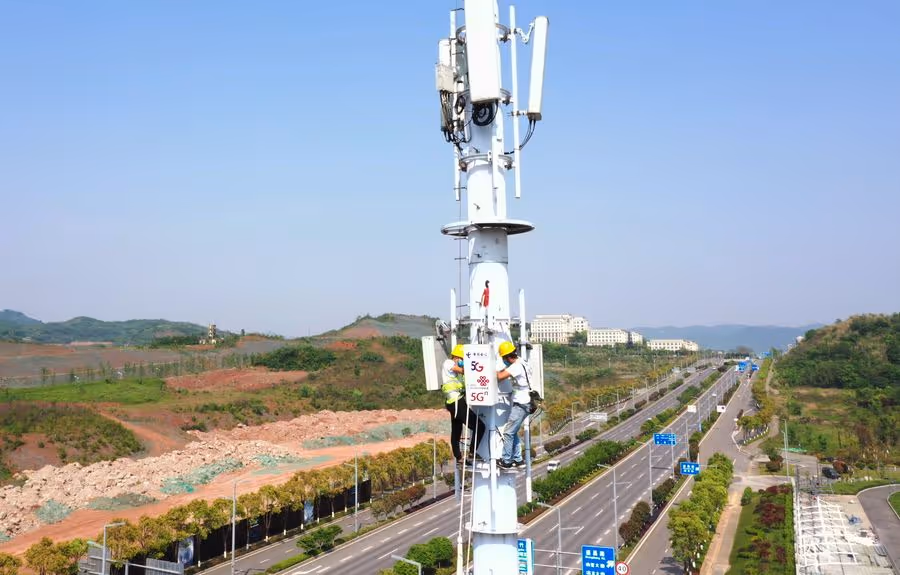
Figure 1. Construction of a 5G base station at Chongqing Hi-tech Zone in Chongqing, Southwest China
GPS is widely known for its role in navigation, location tracking, and mapping, but many were not aware of its function in providing precise time, intervals, and frequency information critical to our telecommunication infrastructure. Each GPS satellite contains several atomic clocks that deliver precise time information and enables users to determine the time to within 100 billionths of a second. This helps to facilitate the time synchronization between the base stations, allowing mobile phones to share limited radio spectrum more efficiently. Telecommunication providers also need it to coordinate the precise call handoffs between different cellular networks, which is essential to its operation and scalability. Without it, mobile calls and video broadcasting would experience heavy degradation and the networks would become spectrally inefficient; the impact would be felt globally.
While fiber-optics and 5G data transport networks are being deployed throughout the globe, these terrestrial networks have limitations in terms of coverage and end user service capacity. It is much slower to roll out fiber or 5G in rural areas compared to urban and suburban areas due to the cost and the speeds of service offered vary. Satellite communications have become an increasingly viable option. With the rapid development of LEO satellites that fly very close to Earth, satellites are able to maintain a stable connection and deliver speeds closer to fiber, with lower lag time, or latency, when compared to GEO satellites. Starlink, SpaceX's LEO satellite broadband business, can be seen as a powerful complement to the terrestrial communications networks. With a growing demand for connectivity globally, satellite communications are expanding capabilities to bring billions of consumers and businesses online, enabling digital infrastructure on an unprecedented scale.
Another example of digital infrastructure that benefits from satellite connectivity is IoT devices. While there have been many terrestrial and satellite-based networks launched to service these devices, both platforms have encountered challenges on cost, coverage, and performance. Totum Labs, a Space Capital portfolio company, has developed a groundbreaking sensor-to-satellite connectivity. Powered by its own satellite constellation and a revolutionary DMSS endpoint tracker-on-a-chip, Totum has successfully demonstrated a working bi-directional link for both indoor and outdoor coverage. This is a step change for the global IoT connectivity framework allowing direct communication between the endpoint to the satellite constellation anywhere on Earth expanding the use cases, lowering the costs per connected device, and supporting missions with a battery life of 10+ years. Totum will help unlock the market potential of IoT for low-cost global asset tracking, in industries like fleet management, infrastructure monitoring, and supply chain logistics.
R3-IoT, another Space Capital portfolio company, allows organizations to access operational data by automating the collection at the sensor for mission critical operations using both satellite and terrestrial communications. Businesses rely heavily on the internet and all the advantages it brings, such as monitoring, communications, and analysis. However, there are a wide range of industries including Aquaculture, Energy, Environmental Monitoring, Rural Health, and Utilities that have geographically distributed assets in harsh environments and operate in areas without reliable connectivity or basic network coverage. This lack of infrastructure makes it challenging for businesses to digitize operations, reduce cost, manage risk, and achieve innovation at scale. Many companies lack the in-house skills and budget to build complex bespoke solutions themselves. R3’s technology provides 24/7 connectivity and the up-to-date information that is essential for the leaders or operational management to make informed decisions.
Agriculture
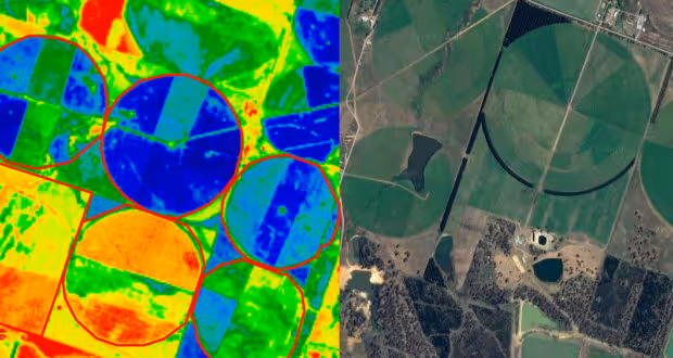
Figure 2. Satellite data is changing the face of precision farming
The Agriculture industry is continuously growing to meet the demands of our expanding population. However, farmers face challenges in improving yields, reducing waste, and increasing financial returns. Satellite data can help agriculture in a number of ways, such as helping farmers manage unpredictable weather events and to prepare for environmental conditions like floods and droughts. From space, satellites monitor not only the current condition of global weather, but also the future. Planet Labs, a Space Capital portfolio company provides the highest frequency satellite data commercially available, captured several times a day using a fleet of over 200 earth imaging satellites. The persistent monitoring and high resolution imaging capabilities help farmers understand both the short and long term impact of land-atmosphere interactions on soil to better determine how the frequency and severity of drought may change, enabling them to plan ahead while at the same time reducing costs and avoiding potential environmental issues.
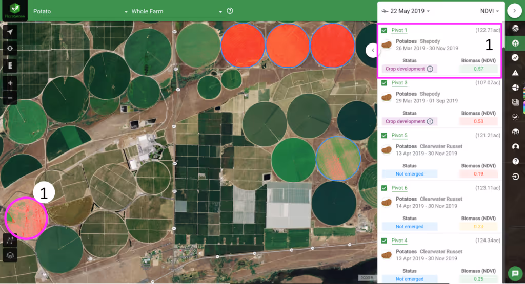
Figure 3. Regrow’s Farm-level, field performance analysis. Pivot 1 has already emerged and is so far best-performing
Several applications that are being implemented in farming using space data include soil moisture monitoring, precision farming, fertilization & water management, crop growth optimization, and autonomous tractors. Soil moisture is the basis of many dependent farming decisions and conventional measurements of the moisture are limited to specific points of location. Satellites provide a broad picture in frequent intervals to understand the dynamic nature of soil variability. Since different crops need different amounts of fertilizer for optimum growth, satellite measurements can help farmers quickly identify which field (and sections within a field) require more attention. At the same time, satellites monitor water and help farmers know where it should be distributed to prevent over-irrigation and help conserve an increasingly limited water supply. This helps farmers know exactly what to grow, when and how, resulting in better crop yields and far less waste. Using satellite imagery, Regrow, a Space Capital portfolio company, can help farmers examine both the historical and current local conditions, model, measure, and verify the impact of management decisions on soil and ecosystem health, so they can initiate prescriptive practices and alerts to help with optimal irrigation or fertilization. In addition to imagery, farmers also rely on IoT devices to provide ground truth data and highly localized insights. Many of these services face gaps in coverage and experience unreliable connectivity. Communications satellites provide an alternative and redundant capability to ensure high quality data is driving key decisions and to avoid operational downtime. Leveraging satellite technology, there is also no longer a need for farmers to physically drive a tractor through the fields. Bear Flag Robotics can turn any tractors into an autonomous vehicle and uses satellite data to do robust route planning, which maximizes efficiency, saves fuel and eliminates excessive tilting.
The Oil and Gas industry is geographical in nature and the companies have a long history of leveraging geospatial data. The use of spatial analysis can help improve the cost-efficiency in their core operations and deliver timely information to facilitate critical decision making. Oil and gas operations are segmented into three sectors – Upstream, Midstream, and Downstream and they each use geospatial data differently. Upstream covers both exploration and production; Midstream connects the upstream and downstream sectors with the pipeline processing, storage, and transportation; and Downstream focuses on refining as well as sales and distribution to customers. In Upstream, producers use optical, seismic, and radar data to first determine where to purchase new oilfields and the best locations to place well heads. By combining location data with past production numbers, companies can generate an accurate assessment of current production capabilities that allows them to determine extraction estimates, competitor performance, and anticipate how the production rate will affect future prices. In Midstream, satellites monitor vegetation encroachment throughout pipeline development to signal required maintenance and to bring immediate attention to pipe leaks. In Downstream, companies use satellite imagery to conduct new site planning, enabling them to strategically build out their refining facilities, pipeline path and shipping routes and update the safety protocols. They also use demographic data, traffic analysis and competitor locations to determine the most effective placement of new gas stations.
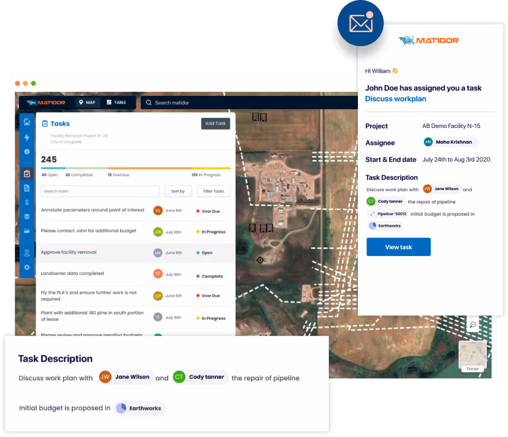
Figure 5. Matidor helps operators to deliver projects with efficiency and cost saving using satellite data
The long-term trend away from fossil fuels means that reducing operational costs is a top priority and increasingly a challenge for the Oil and Gas industry, and better project management in Midstream and Downstream operations is much needed in controlling budgets, improving efficiency, and eliminating low value activities. There has been no easy way to coordinate operational activities, spending, and external vendors across a distributed set of sites. Spreadsheets and manual record keeping are still around and using complicated mapping software tools is far from user-friendly for non-technical users. Matidor, a Space Capital portfolio company, has developed a project operation and collaboration platform that unlocks siloed information across multiple stakeholders. They provide oil & gas operators with easy to use geospatial drawing tools, smart reporting, and standardized workflows that help them update project status, track expenses, supervise sites, and assign tasks in real-time. The importance of collaboration is emphasized as Matidor gives superintendents, environmental consulting professionals, and other key decision makers a birds eye view across an organization and its geographic footprint.
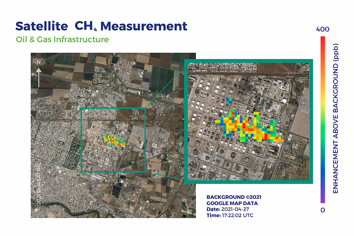
Figure 6. GHGSat helps companies to monitor emissions and comply with regulatory standards using satellite data
The Oil & Gas industry is one of the largest contributors to climate change through methane flaring and leaks associated with daily operations. Methane is a highly potent greenhouse gas with more than 80 times the warming power of carbon dioxide. Monitoring and addressing methane emissions can yield a near-term reduction in the rate of warming, easing the efforts to decarbonize the world’s energy and transport systems while also delivering air quality benefits. GHGSat, a Space Capital portfolio company, collects high precision emissions data at a fraction of the cost of existing alternatives from its satellite and aircraft sensors and the environmental data is delivered to customers through a highly automated infrastructure along with tailored analytical insights. The unique measurements are collected at short-wave infrared light (SWIR) wavelengths compared to standard imagery within the visible light wavelengths. This raw output is then post-processed to generate a surface reflectance in the SWIR and greenhouse gas concentrations per pixel in the atmosphere, and presented to the customers in “concentration maps” to visualize the methane distribution. This constant monitoring helps companies plan maintenance, maintain production, mitigate risk, optimize resources, and respond to emergencies.
.avif)